

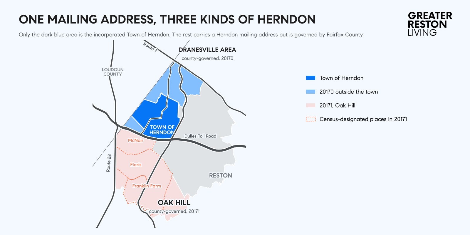
A Herndon mailing address can put you in any of three places, and only one of them is the Town of Herndon. The town is an incorporated municipality of about 4.3 square miles north of the Dulles Toll Road, with its own mayor, council, police department and town tax. South of the Toll Road, the 20171 ZIP code is Oak Hill. North and west of the town, part of the 20170 ZIP code sits outside the town limits in what we call the Dranesville area. Fairfax County governs both of those areas directly, the same way it governs Reston.
Homeowners in each area pay different tax bills, call different police departments, answer to different zoning authorities and get trash pickup from different providers.
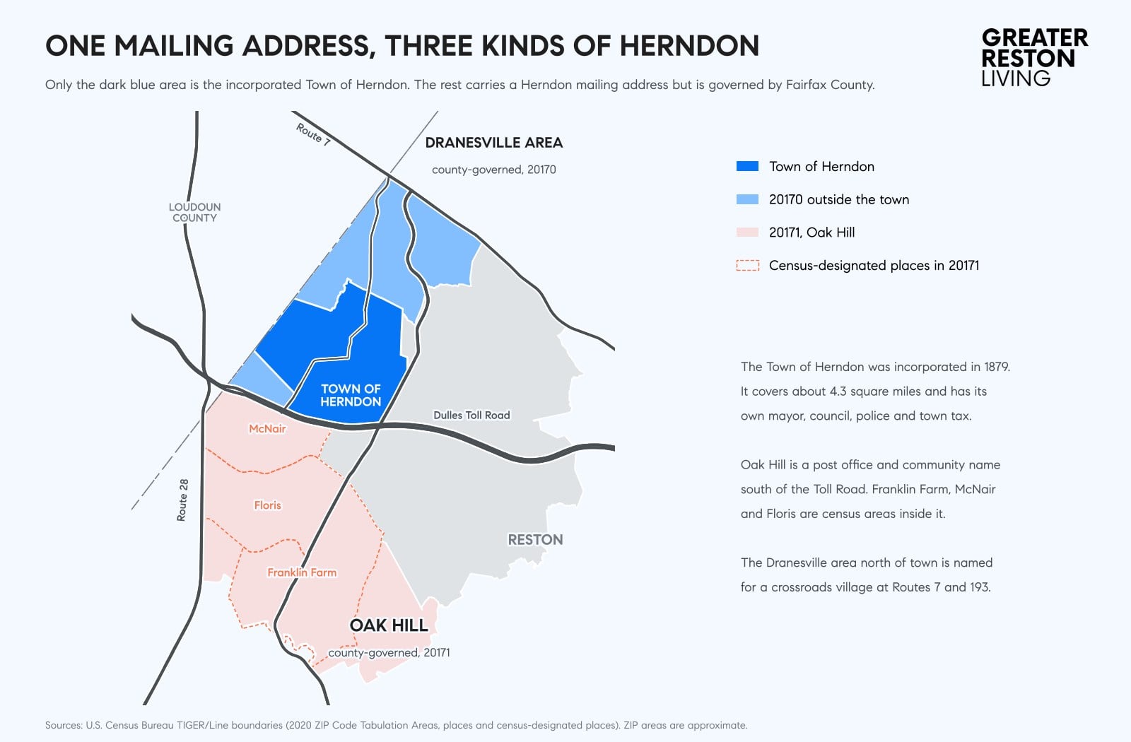
The Town of Herndon is an incorporated town north of the Dulles Toll Road
Herndon incorporated in 1879 and took its name from Commander William Lewis Herndon, who went down with his ship, the SS Central America, in 1857, according to the Town of Herndon’s history page. The town covers about 4.3 square miles, and the Dulles Toll Road forms most of its southern edge. The Census Bureau estimates its population at about 25,500 as of July 2025.
Under its charter, voters elect a mayor and six council members in November of even-numbered years. In the Nov. 3 election, Mayor Keven LeBlanc won another term and five of the six council seats went to newcomers, as we covered in our Herndon Town Council election results.
The town runs a long list of its own services: the Herndon Police Department, water and sewer service, trash, recycling and leaf collection, street maintenance and snow removal, zoning and building permits, parks, the Herndon Community Center, the Herndon Centennial Golf Course and town elections. The town also writes its own comprehensive plan, and our explainer covers Herndon 2050, its plan for downtown and the area around the Herndon Metro station.
Town residents pay for those services through a town real estate tax of 27 cents per $100 of assessed value, on top of the Fairfax County rate. Fairfax County still runs the public schools for town residents, and the town tax appears on the same county bill. On a home assessed at $700,000, the town tax adds about $1,890 a year. Our guide to property taxes on a Reston home breaks down the county side of the bill.
Oak Hill is the 20171 area south of the Toll Road, and Fairfax County governs it
South of the Dulles Toll Road, the 20171 ZIP code covers roughly 52,000 people in neighborhoods such as Franklin Farm, Fox Mill, McNair and Floris. The U.S. Postal Service lists Herndon as the recommended city name for 20171 and also recognizes Oak Hill, and the ZIP code’s only post office, on McLearen Road, carries the Oak Hill name. Many residents call the area Oak Hill, and in our experience more of them simply say Herndon.
Oak Hill has no government of its own, and its boundary is the 20171 ZIP code, the area the Oak Hill post office serves. It is a community name and a postal address, not a town. Inside it, the Census Bureau draws several census-designated places, which are statistical areas used for counting purposes only:
- McNair: about 21,600 people, bounded by the Toll Road on the north and Route 28 on the west
- Franklin Farm: about 19,200 people, roughly 4.75 square miles
- Floris: about 8,300 people, around Centreville Road and West Ox Road
- Sully Square, a smaller area, and part of Difficult Run, which takes in the Fox Mill area
Most of the neighborhoods are defined by their homeowners associations. Franklin Farm, Fox Mill and dozens of smaller communities each have their own HOA, covenants and common areas.
Fairfax County provides local government in Oak Hill the same way it does in Reston. The Fairfax County Police Department patrols it, the county’s zoning ordinance and comprehensive plan govern what can be built, and the Fairfax County Park Authority runs the parks, including Frying Pan Farm Park on West Ox Road. Oak Hill homes pay no town tax, and trash pickup comes through the HOA or a private hauler.
Oak Hill is also split among three seats on the Fairfax County Board of Supervisors. McNair sits in the Dranesville District, the Fox Mill area and parts of Floris and Franklin Farm sit in the Hunter Mill District, and the core of Franklin Farm sits in the Sully District.
North and west of the town, the Dranesville area is county land with a Herndon address
The 20170 ZIP code covers the Town of Herndon and more. Outside the town limits, 20170 runs north and east toward Route 7 and includes a smaller pocket west of town, north of the Toll Road. We call the northern part the Dranesville area, after the old crossroads village at Routes 7 and 193. Washington Drane settled there around 1810, and the Dranesville Tavern, built in 1823, still stands on Leesburg Pike. The Fairfax County Park Authority owns it.
The Census Bureau counts about 11,800 people in the Dranesville census-designated place and about 6,200 in Hutchison, the pocket west of town. Like Oak Hill, both areas get county police, county zoning and county parks, and neither pays the town tax.
Dranesville is also the name of the Board of Supervisors district that covers the Town of Herndon and most of the area north of it. Supervisor Jimmy Bierman represents the district, so a town resident and a neighbor just outside the town limits often share a supervisor even though only one of them has a mayor.
Fairfax County assigns Herndon schools by address, in town and out
Fairfax County Public Schools serves every Herndon address, in and out of town, and assigns students by address. Most of 20170, including the town, attends Herndon High School, and some addresses near Route 7 are zoned to Langley High School. In 20171, students attend Westfield, Oakton, South Lakes or Chantilly depending on the street, and a small part of McNair goes to Herndon High.
Skyview High School, on Education Drive in the Floris area, opened in fall 2026 for students who chose to enroll. Its assigned boundary takes effect in the 2027-28 school year and draws from the Westfield, South Lakes and Chantilly attendance areas, according to FCPS. Check any address with the FCPS boundary locator before you buy.
The three Herndons side by side
| Town of Herndon | Oak Hill (20171) | Dranesville area (20170 outside town) | |
|---|---|---|---|
| Local government | Town mayor and council, plus Fairfax County | Fairfax County | Fairfax County |
| Police | Herndon Police Department | Fairfax County Police | Fairfax County Police |
| Zoning and planning | Town of Herndon | Fairfax County | Fairfax County |
| Real estate tax | County rate plus 27 cents per $100 | County rate | County rate |
| Trash pickup | Town collection for most homes | HOA or private hauler | HOA or private hauler |
| Parks | Town parks and county parks | County parks | County parks |
| Supervisor district | Dranesville | Dranesville, Hunter Mill or Sully | Mostly Dranesville |
| Schools | FCPS | FCPS | FCPS |
The tax bill shows whether a home is in the town
A Herndon mailing address and a 20170 ZIP code leave open whether a home sits inside the Town of Herndon, and the tax record answers it. Homes inside the town carry the town’s 27-cent levy on their Fairfax County real estate bill, and the county’s real estate assessment search shows each property’s tax district. The town’s own maps show the limits street by street, and nearly everything south of the Dulles Toll Road falls outside the town.
We confirm the tax district on every Herndon address we show buyers, because a home inside the town pays a different yearly tax, gets a different police department and sits under a different government for development decisions.
Loudoun County has a different Oak Hill
Oak Hill is also the name of James Monroe’s estate near Aldie in Loudoun County, a National Historic Landmark about 20 miles west. “Oak Hill, Virginia” can mean either place, so we add “Herndon” or “Fairfax County” when we mean the 20171 area.
The three Herndons differ in taxes, elections, zoning and police
For daily life, the three Herndons blur together. Residents shop at the same stores on Elden Street and Centreville Road, ride the Silver Line from the same stations and use the same W&OD Trail. The three areas differ at a few specific moments: the tax bill each summer and December, a town election every other November, a rezoning hearing that one government holds and the other does not, and a call to the police.
If you are weighing a move to Herndon and want to know which Herndon a home sits in and what that means for you, reach out to the Greater Reston Living team at Compass.
See something missing or wrong? Email us at [email protected] and we will check it and update the post.