

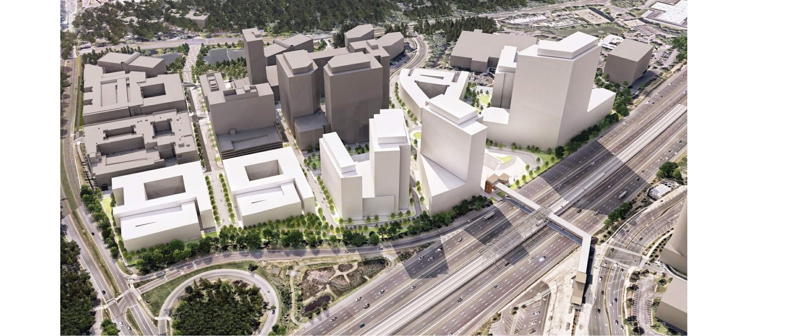
Step off the south entrance of the Reston Town Center Metro station and you are standing between two office parks built in 1998, four buildings and their surface parking lots wrapped around a traffic circle at the end of Edmund Halley Drive. A plan to replace all of it is working its way through Fairfax County right now, and the case file holds a status update nobody has reported.
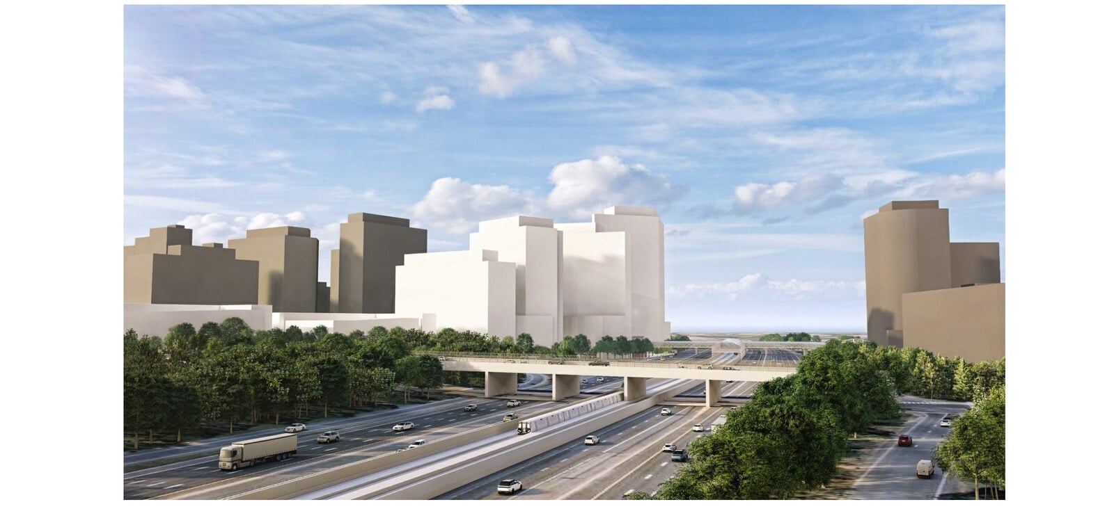
The rendering above is an illustrative massing study from the applicant’s conceptual development plan. The county has not approved any building designs.
The project is Reston Crossing, application RZ-2026-HM-00006, filed in March by two affiliates of Bernstein Management Corporation. I pulled the complete case file from the county’s records this week, including the 53-sheet development plan and the applicant’s 21-page justification letter. Here is the plan, the history behind it, and where it stands as of this week.
Where the application stands
Three dates tell the story so far. Bernstein filed the rezoning on March 5, 2026. The county formally accepted it for review on May 18. And as of this week, the record status reads Waiting for Resubmission, which means county reviewers have finished their first pass, sent comments back, and the ball sits with Bernstein to file a revised plan.
That status is routine for a project this size. Nearly every large Reston rezoning goes through multiple submission rounds; Commerce Metro Center is on its fifth. No Planning Commission or Board of Supervisors hearing is scheduled, and none will be until the revisions satisfy county staff. The practical translation: the plan described below is the opening bid, some details will move, and hearings are months away at minimum.
A plan that failed once, now bigger
This land has been through this process before. The county approved a Reston Crossing rezoning in June 2019 for the eastern 14 acres, then owned by Tishman Speyer: up to 2,015,000 square feet with 1,194 homes across seven buildings. The first phase even got its final development plan approved. Not one building went up. In its own filing, the applicant attributes that to evolving market conditions, significant infrastructure requirements, and phasing complexities.
Bernstein bought its way in through two purchases, the first in December 2024 and the second in April 2025, picking up all four office buildings for a combined sum that news coverage put near $90 million. Rather than dust off the 2019 approval, the company hired a new design team, invoked Bob Simon’s founding principles for Reston as its stated design drivers, and refiled for the whole 23.9 acres under a single, unified plan.
The new numbers are larger than the old ones. Up to 3,120,141 square feet at a 3.0 floor area ratio, split 52 percent residential and 48 percent commercial: as many as 1,620 apartments, 1,476,000 square feet of Class A office, and 31,000 square feet of retail. Sixteen percent of the homes would be workforce or affordable dwelling units under Reston’s transit station area housing policy, which works out to roughly 260 units at full buildout.
Kathy and I walked through the whole Reston Crossing story on the podcast when the filing first landed, including how it fits with everything else changing around the station.
The block map
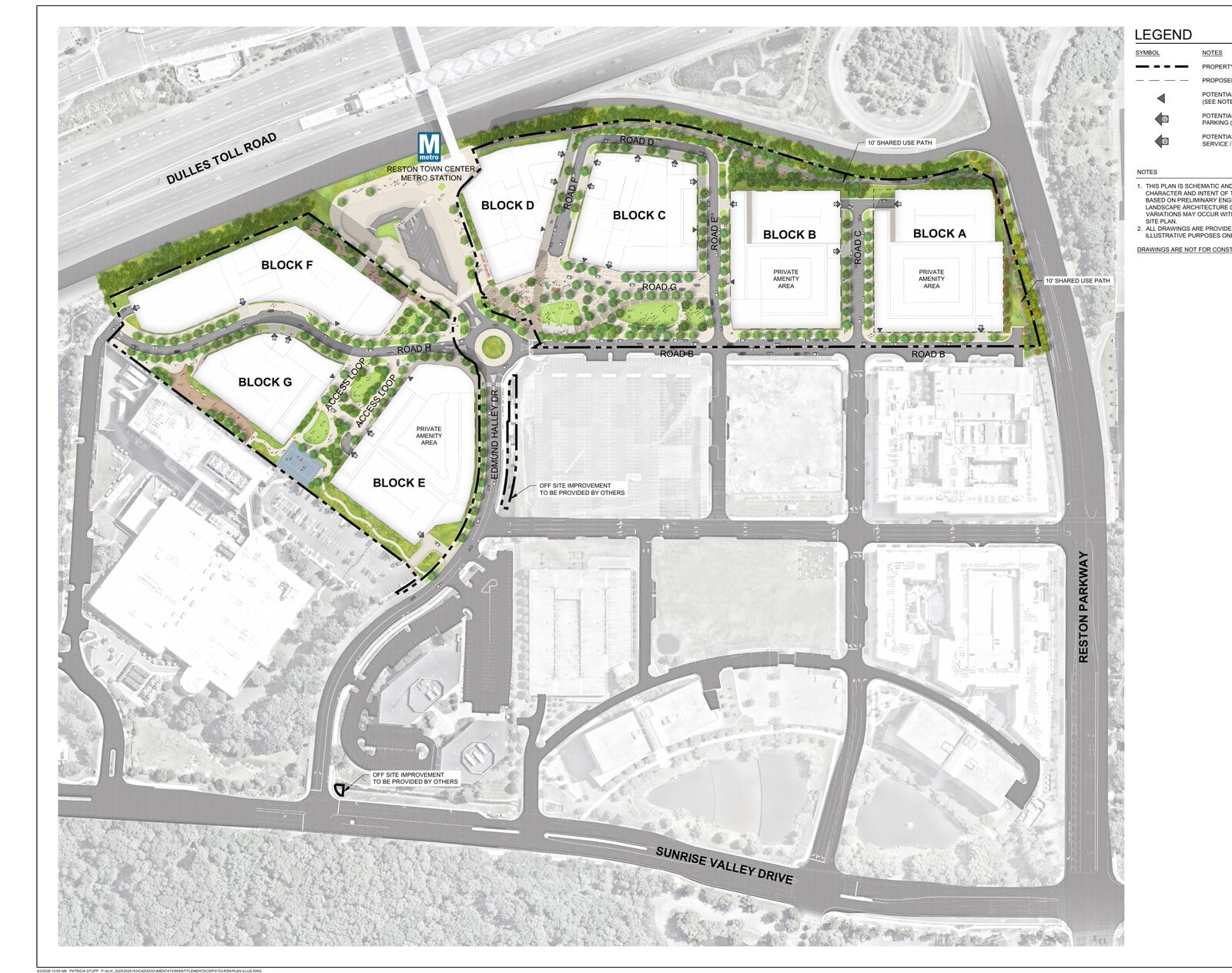
The plan organizes the site into seven blocks, lettered A through G, wrapping the station entrance and the county-owned bus loop parcel. From the justification letter:
- Block A: residential, up to 380 units and 110 feet, at the site’s eastern end along Reston Parkway.
- Block B: residential, up to 320 units and 110 feet, with a public vehicle route threaded through the future building.
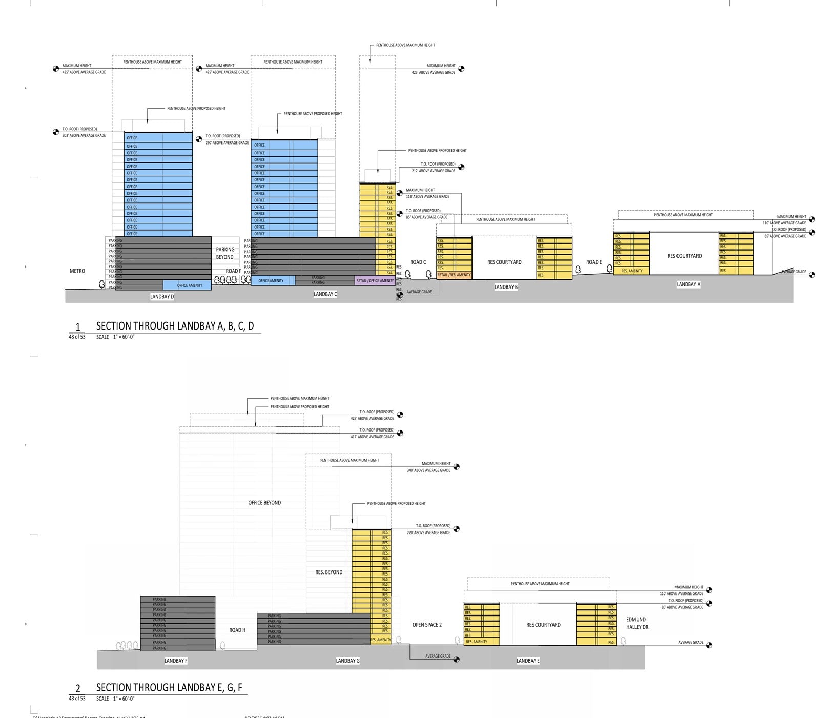
- Block C: the big mixed-use block, up to 638,141 square feet combining 235 homes, 406,000 square feet of office, and 16,000 square feet of retail, at up to 425 feet.
- Block D: an office block of up to 460,000 square feet at up to 425 feet, oriented to the station as the project’s front door, with an activated ground floor and a possible direct pedestrian connection into the Metro entrance to be worked out at final design.
- Block E: residential, up to 355 units and 110 feet, on the western site.
- Block F: the largest office block, up to 625,000 square feet at up to 425 feet, fronting a linear green at the station and reserving room for the future Town Center Parkway extension on its western edge.
- Block G: residential, up to 330 units at up to 340 feet.
The tallest buildings cluster at the station and taper outward, the same logic that put Halley Rise’s height along the Toll Road. At 425 feet, the tallest Reston Crossing towers would answer the Fannie Mae and Reston Next buildings on the north side of the corridor, and the applicant says so directly, describing a balanced skyline composition across the Dulles Toll Road.
Four parks with names
The public realm plan commits about 4.75 acres, roughly a fifth of the site, to four named, publicly accessible spaces.
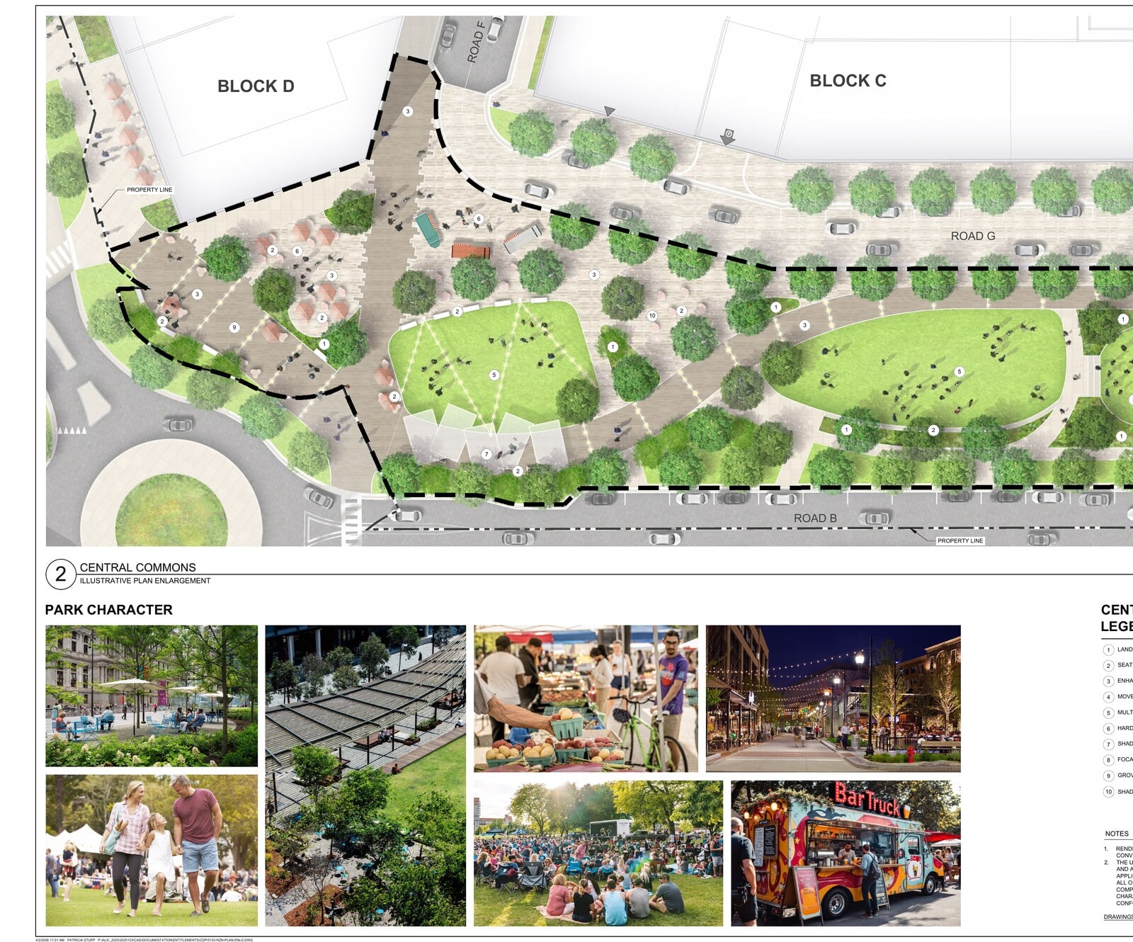
The Central Commons, at about 64,400 square feet, sits in the middle of the eastern blocks and is designed as the civic heart: a multipurpose lawn, a hardscaped plaza, a shade structure, and a focal element marking the entrance from the station. The street on its northern edge, Road G, is drawn as a woonerf, a curbless shared street that lets the park spill to the face of the Block C tower during events.
The Canopy Trail runs about 64,300 square feet as a linear greenway along the Toll Road and Reston Parkway edges, carrying a 10-foot shared-use path with seating and fitness stations from Reston Parkway to the station. Boardwalk Green, about 27,400 square feet, fills the gap south of the bus loop between the east and west sites. Crossfields Park, about 51,000 square feet on the western site, gets the neighborhood amenities: a dog park, a sports court, play elements, and a green buffer against the CoreSite data center next door.
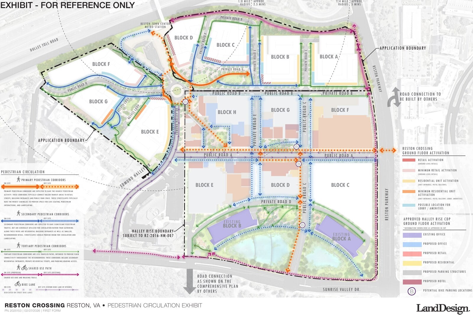
All told the plan claims 25 percent open space against the 20 percent the PDC zoning district requires. Retail is deliberately modest and concentrated near the station and the Central Commons; the justification letter states outright that it is scaled to serve the neighborhood without competing against Halley Rise’s larger retail program, including the Wegmans two blocks south.
One neighborhood with Halley Rise
The filing reads less like a standalone project and more like the northern half of a district. Road B, the east-west street that separates Reston Crossing from Halley Rise, gets rebuilt as an activated, pedestrian-oriented corridor with crosswalks knitting the two projects together. The applicant leans on the pairing for its planning math too: the Comprehensive Plan wants a 50:50 residential-to-commercial mix across the whole South Subdistrict, and Reston Crossing’s 52 percent residential balances against Halley Rise’s 52 percent commercial to hit it.
A new Road H would run from the traffic circle to a future western entrance, graded to accommodate the long-planned Town Center Parkway underpass beneath the Toll Road when the county builds it. The plan also rebuilds the Reston Parkway trail with a double row of trees and adds a shared-use path along the Toll Road edge.
Parking tells you what kind of place this intends to be. The applicant is asking for reduced ratios across the board, as low as 0.8 spaces per apartment, with all parking structured, wrapped, or underground, and a transportation demand program targeting roughly 45 percent fewer single-occupant vehicle trips than standard rates. Structures line the Toll Road and data center edges, doubling as noise shields for the homes and parks inside.
The fine print worth knowing
Three items in the waiver list deserve attention as this moves forward. The applicant wants relief from the 200-foot residential setback normally required from an interstate highway, arguing the station and bus loop leave no room to comply; the county’s answer will shape how close homes sit to the Toll Road, and the case file includes a noise impact analysis for exactly this reason. A second modification would let residential exceed 75 percent of principal-use floor area, a technicality of the PDC district where offices count as the principal use. And the tree preservation target gets a requested deviation, since keeping the required canopy on a 75 percent paved site while building three million square feet does not pencil.
None of these is unusual for a transit station area project. Each is the kind of detail that moves between submission rounds, which is exactly where this application sits now.
What it means if you live here
Nothing changes soon. The existing office buildings stay open and leased through the entitlement process, the project is explicitly phased to move with the market, and the 2019 experience is a reminder that an approval is not a groundbreaking. For anyone who bought at Halley Rise or is weighing it, this filing is mostly good news: it would complete the street grid, double the park network within a short walk, and put the neighborhood’s density where transit can absorb it. For the broader market, 1,620 units at a Metro station is the largest single housing proposal pending anywhere in Reston right now, and roughly 260 of those homes would be committed affordable.
We will track the resubmission, the staff report when hearings finally get scheduled, and every revision to the numbers above. The full case file, including the development plan sheets and the justification letter, is available through the county’s PLUS record for RZ-2026-HM-00006, and status changes appear on the Hunter Mill District land use page. For the neighborhood context, our deep dives on Halley Rise and the RTC Next expansion cover the other two corners of this station area. If you are thinking about what a decade of construction at the Metro means for buying or selling nearby, that is a conversation we have every week. Reach out any time.