

Homeowners in unincorporated Fairfax County, which includes all of Reston, now get 25 percent off the premium when they buy flood insurance through the federal program. On October 1, FEMA moved the county up to Class 5 in its Community Rating System, and the county’s discount rose from 20 percent to 25 percent for policies issued or renewed on or after that date. Five other Virginia localities hold Class 5. None in the state rates higher.
For most of Reston and Herndon, the discount applies to a policy no one requires. Very few homes here sit in a FEMA high-risk flood zone, federal rules require flood insurance only inside those zones, and standard homeowners policies exclude flood damage. Outside a mapped zone, each owner decides alone whether to carry coverage unless a lender asks for it.
The 25 percent discount covers Reston, not the Town of Herndon
FEMA’s Community Rating System, or CRS, grades local floodplain programs from Class 10 to Class 1 and cuts National Flood Insurance Program premiums by 5 percent for each class a community climbs. Fairfax County joined in 1993 and estimates that the program saves county residents more than $1.1 million a year. The county earns its rating through work such as mapping, buying out homes that flood again and again, and public outreach. Its 2026 progress report notes that all five of its severe repetitive loss properties have now been bought and torn down.
Under Risk Rating 2.0, the pricing system FEMA adopted in 2021 that rates each building on its own flood risk, the county’s discount applies the same way inside and outside a mapped flood zone. A house on a hilltop in North Reston gets the same 25 percent off as a house beside a stream.
The Town of Herndon runs its own floodplain program with FEMA, separate from the county’s, and the town does not appear on FEMA’s October 2026 list of CRS communities. Homes inside town limits get no CRS discount. A Herndon mailing address does not mean a home sits inside the town, though. Large parts of the 20170 and 20171 ZIP codes lie outside town limits in unincorporated Fairfax County, and those homes qualify for the county’s 25 percent.
A high-risk flood zone means a 1 percent chance of flooding in any year
FEMA draws its zones on a Flood Insurance Rate Map, or FIRM, and three of them cover Reston and Herndon:
- Zone A and Zone AE. Together these make up the Special Flood Hazard Area, FEMA’s high-risk zone, where the agency calculates at least a 1 percent chance of flooding in any given year. AE areas carry a base flood elevation, the height FEMA expects water to reach in that flood. Over a 30-year mortgage, 1 percent a year works out to roughly a 26 percent chance of at least one flood.
- Shaded Zone X. Moderate risk, with a 0.2 percent annual chance, often called the 500-year floodplain.
- Unshaded Zone X. Minimal mapped risk. Most of Reston and Herndon falls here.
A 1 percent chance resets every year, so a home in the zone can flood two years running.
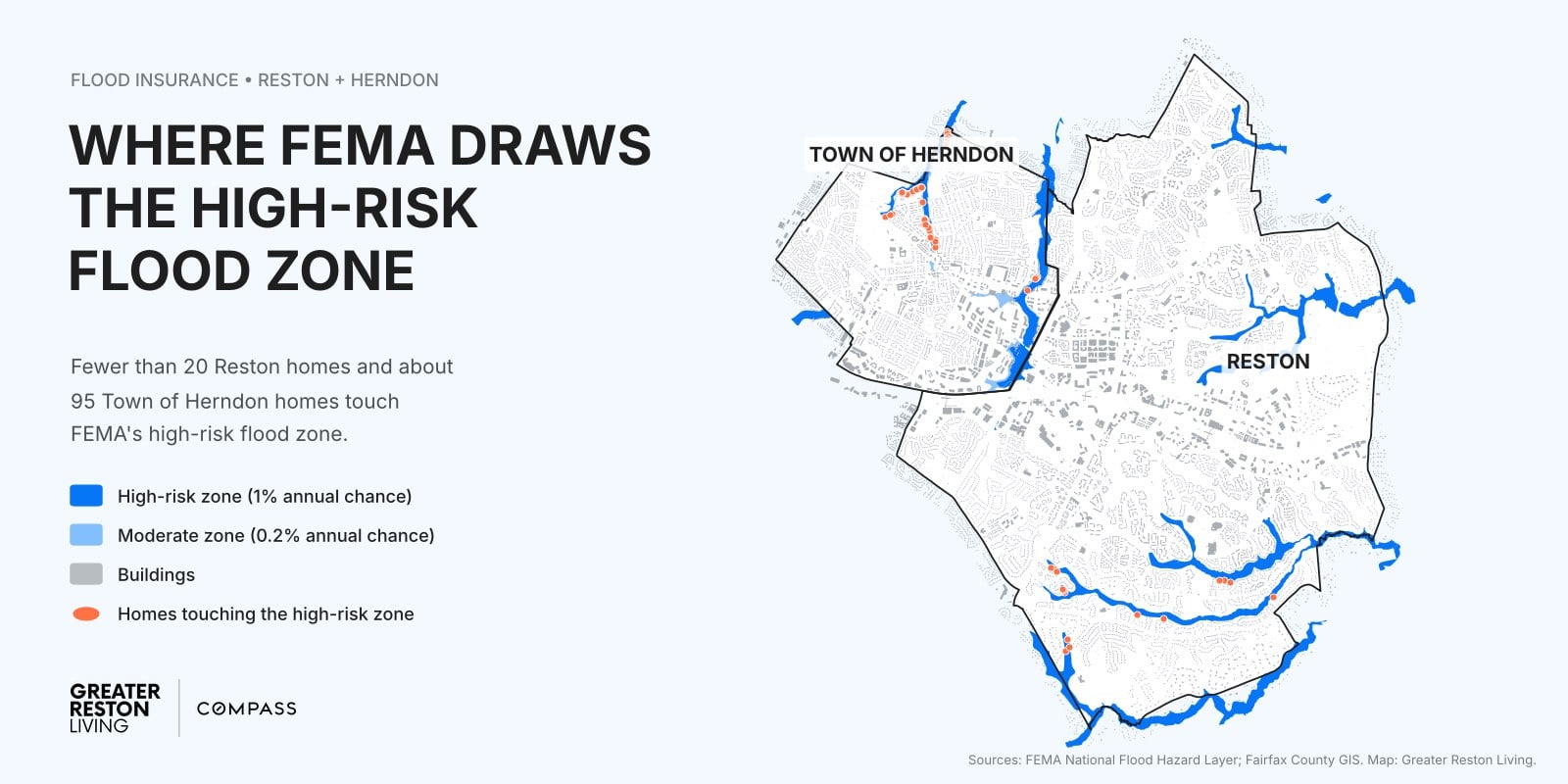
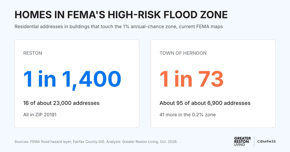
Fewer than 20 Reston homes and about 95 Town of Herndon homes sit in the high-risk zone
We laid FEMA’s current flood zones over Fairfax County’s building footprints and address records. Inside Reston’s census boundary, 16 of roughly 23,000 residential addresses, about one in 1,400, fall in a building that touches the high-risk zone. All 16 are in South Reston’s 20191 ZIP code, in pockets along stream valleys including The Glade and Snakeden Branch. In our overlay, no multifamily building in Reston touches the zone.
The Town of Herndon has about 95 such addresses out of roughly 6,900, or about one in 73. Most sit in townhouse rows along Folly Lick Branch and nearby streams, with a few backing onto Sugarland Run. Another 41 town addresses fall in the shaded 0.2 percent zone.
The zones cover far more land than housing. The high-risk zone takes in about 4 percent of Reston’s land and about 5 percent of Herndon’s, nearly all of it stream valley with no houses on it.
Treat these counts as close estimates rather than a property-by-property ruling. A building that grazes the edge of the zone counts here, and a townhouse row counts as one building, so a row whose end unit touches the zone puts every home in the row in the count. Some owners have also won a Letter of Map Amendment, a FEMA ruling that takes a specific building out of the high-risk zone when a survey shows it sits above the flood elevation, and the public map data does not reflect every one of those.
FEMA is redrawing Fairfax County’s flood maps
FEMA released preliminary maps for the county in 2021 and revised them in August 2024. On September 25, 2026, it opened a 30-day comment period on an appeal covering part of Tripps Run near Falls Church. Once FEMA settles that appeal, it issues a Letter of Final Determination, and the county then has six months to adopt the new maps. The county has already notified the owners of every structure whose flood risk will rise or fall under the preliminary version.
The zone line will move for some houses. Under Risk Rating 2.0 a flood zone no longer sets the price of a policy, but it still decides whether a lender requires one. FEMA’s Flood Map Changes Viewer shows how the preliminary maps differ from the current ones for any address.
Check any address on FEMA’s map or the county’s viewer
Looking up a zone takes a few minutes and requires no account:
- FEMA’s Flood Map Service Center. Type the address to pull up the flood map for that location and the zone the house sits in.
- Fairfax County’s flood hazard map viewer. It shows the same FEMA zones on the county’s base map, with parcel lines, which helps on a lot near the edge of a zone.
- Virginia’s Flood Risk Information System. The state’s version, run by the Department of Conservation and Recreation.
A lender runs a flood determination before closing on a mortgage, and the report states whether the building sits in the high-risk zone. Ask the lender to run it early in the contract period rather than days before closing.
Do not expect the seller to tell you. Virginia’s Residential Property Disclosure Statement says the owner “makes no representations” about whether a property sits in a special flood hazard area and puts the research on the buyer. Since January 2022, an owner who knows the home is a “repetitive risk loss” structure, meaning the federal program paid two or more flood claims of more than $1,000 on it within any 10-year period, has had to tell the buyer. General Assembly members have tried to widen that rule, most recently with a 2025 bill that a House subcommittee tabled.
Federal rules require flood insurance only inside the high-risk zone
A mortgage from a federally regulated lender, or one backed by Fannie Mae, Freddie Mac, FHA or VA, on a building in Zone A or AE comes with a flood insurance requirement. Outside those zones, flood insurance is optional unless your lender asks for it. Paying off the mortgage ends the requirement, unless the property once received federal disaster aid that required keeping flood coverage.
Nearly a third of federal flood claims come from outside high-risk zones
FEMA’s FloodSmart site says almost one-third of National Flood Insurance Program claims from 2014 through 2024 came from outside the high-risk zones. The same page puts the average claim payment from 2020 through 2024 at $82,614. Fairfax County’s flood guidance warns, “Anywhere it can rain, it can flood. Even outside of floodplains!”
On September 8, 2011, the remnants of Tropical Storm Lee dropped 6.22 inches on Reston by 6:30 p.m., according to WeatherBug stations. Lawyers Road, Hunter Mill Road, Sunrise Valley Drive and Sunset Hills Road closed, and cars sat fully submerged at the western end of the Reston North Park and Ride. On July 8, 2019, a morning downpour left nearly three feet of water standing in the Wiehle-Reston East station parking lot, up to the windshields of parked cars, by the National Weather Service’s account. By July 19, 2025, the weather service had issued 16 flood watches for the Washington region since May, which the Capital Weather Gang called the most on record.
Those storms flooded roads and parking lots, but the same rain runs off roofs, driveways and streets toward the nearest low spot. On a residential street, that low spot can be a basement stairwell or a window well. The county’s flood protection newsletter also warns that some houses outside floodplains have sewers that back up into basements during heavy rain.
Five situations make a flood policy worth pricing outside a flood zone
- The house sits in the shaded 0.2 percent zone, or just downhill from a mapped zone. The 41 Herndon addresses in that moderate band face lower odds than the high-risk zone, not zero.
- The basement is finished and below grade. Basements with window wells, or at the bottom of a slope, take water first. Federal flood policies cover only a short list of things in a basement: the furnace, water heater, electrical panel, sump pump, foundation walls and stairs, plus a washer, dryer and freezer if you carry contents coverage. They do not pay for finished walls, flooring, carpet, built-ins or furniture down there. FEMA counts a space as a basement only if its floor sits below ground on every side, so a walkout level usually gets full coverage.
- Water has already pooled near the foundation. A lot at the low point of a street or cul-de-sac, or one where the yard ponds after a summer storm, collects runoff from everything uphill. A flood policy pays only when the water meets FEMA’s definition of a flood, described below, so water that collects on your lot alone usually falls to your homeowners policy, if anything covers it.
- A large repair would strain your savings. FEMA has estimated that one inch of water in a home can cause up to $25,000 in damage. Federal disaster aid requires a presidential disaster declaration, and FEMA notes that it typically comes as a low-interest loan you repay.
- You own a condo or townhouse and have not read the association’s policy. Federal flood policies cover condominium and townhouse owners, up to $250,000 for the building and $100,000 for belongings. Read the association’s master policy to see which parts of the unit it already insures, then buy for the gap.
Homeowners insurance excludes flood, and drain backups fall in between
The National Flood Insurance Program defines a flood as water covering two or more acres of normally dry land, or two or more properties, at least one of them yours. A flood policy pays for damage from a flood that size, and a homeowners policy does not.
Drain and sewer backups sit between the two. FEMA says a flood policy covers a sewer backup when a flood in the area causes it, and it does not cover a backup caused by clogged pipes. For a sump pump that fails or a floor drain that backs up without a wider flood, ask your homeowners insurer about a water backup endorsement and its limit.
A new flood policy takes 30 days to start
A policy bought voluntarily takes effect 30 days after purchase, so buying one when the forecast turns ugly does not help that week. FEMA waives or shortens the wait in two cases:
- No waiting period when you buy the policy at or before closing on a mortgage, or when you increase, extend or renew one.
- A one-day wait when a map revision moves your building into the high-risk zone and you buy within 13 months of the new map taking effect. That rule will cover owners the new county maps move into the zone once those maps take effect.
A federal flood policy costs the same from any agent, but private flood insurers set their own prices, so ask for a quote from both. VCU Capital News Service reported in 2025, citing the broker Policygenius, an average Virginia flood premium of $743 a year, and, citing the state Department of Conservation and Recreation, that only 3 percent of Virginia homeowners carry flood insurance. The county’s federal flood program had 3,746 policies in force in February 2026, in a county of more than 1.1 million people.
Congress also has to renew the program on a schedule. Its authority ran out from October 1 to November 12, 2025, and again for three days in February 2026. The current extension runs through December 11, 2026. During a lapse, FEMA keeps paying valid claims but stops selling and renewing policies, which can hold up closings on homes that require flood insurance. Private flood insurers are not bound by the federal deadline and can write a policy during a lapse.
Get a flood quote for the specific house before deciding
- Look up the zone. FEMA’s map or the county viewer, five minutes.
- Ask your agent for a flood quote alongside a price for a water backup endorsement. Reston owners renewing after October 1 should see a 25 percent CRS discount listed on the declarations page, though a policy still phasing up to its full Risk Rating 2.0 price may not see the bill drop by that much.
- When buying, ask the seller for any elevation certificate and flood history, and ask your lender for the flood determination at the start of the contract period.
- Inside the Town of Herndon, the same rules apply without the discount, and the quote still prices your building on its own risk.
We are happy to talk through flood questions on any Reston or Herndon home you are buying or selling.
See something missing or wrong? Email us at [email protected] and we will check it and update the post.