

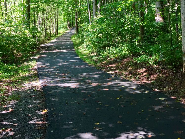
Reston Association maintains 55 miles of paved pathways and natural surface trails. Six of them carry names and marker posts, and five come with printed brochures. Four lakes have walkable loops. The W&OD Trail and the Fairfax Cross County Trail both run through town. All of it is free, and most of it is a short walk from a parking lot where you will not get a ticket.
The Lake Audubon loop includes a set of stairs. The Lake Thoreau loop spends most of its length on residential streets rather than the shoreline. The gray posts along the pathways come in two kinds, and only one of them marks a trail.
This guide covers every marked route with its published distance, the four lake loops, the stream valley trails, the parking at each trailhead, and the rules that apply once you are on the path.
Six named trails run from 1.43 to about 5 miles
Reston Association’s Pedestrian and Bicycling Advisory Committee created the trail marking program. Five of the six routes come with a two-page brochure you can download free. The sixth does not, which we come back to below.
| Trail | Official name | Distance | Type | Park at |
|---|---|---|---|---|
| Blue | Tall Oaks to Lake Anne to North Point | 3.44 miles | Point to point | Tall Oaks or North Point Village Center |
| Green | Reston Town Center to Lake Anne | 1.43 miles | Point to point | Reston Town Center garages or Lake Anne Plaza |
| Pink | North Point Parks Loop | 4.07 miles | Loop | North Point Village Center |
| Purple | South Lakes to Hunters Woods to Polo Club Village | About 5 miles | Point to point | Hunters Woods Village Center |
| Red | Lake Thoreau Loop | 2.1 miles | Loop | South Lakes Village Center |
| Turquoise | South Lakes Village Center to Hunters Woods Center | 4.74 miles | Point to point | South Lakes or Hunters Woods Village Center |
Five of those distances come from Reston Association’s printed brochures. The Purple figure is our own measurement of the route as the association maps it, because the association publishes no distance for it.
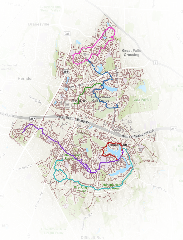
The Blue Trail runs 3.44 miles across north Reston with 45 numbered markers. It leaves Tall Oaks Village Center, passes the Tall Oaks pool, skirts the Hidden Creek Country Club golf course, picks up the Hook Road recreation area and Lake Anne Elementary, crosses the Van Gogh Bridge into Lake Anne Village Center, then heads north through underpasses at Wiehle Avenue and Baron Cameron Avenue to Lake Newport and out to North Point Village Center at Reston Parkway. It is the best single route for seeing how the old and new halves of Reston connect.
The Green Trail is the short one, 1.43 miles and 17 markers, and it is the pedestrian spine between Reston Town Center and Lake Anne Plaza. From Fountain Square it drops under Reston Parkway, runs along New Dominion Parkway and the Wainwright recreation area, passes Lake Anne Elementary and Hickory Cluster, and finishes at the Lake Anne fountain. Walk it in twenty-five minutes. At its southeast corner the brochure marks the W&OD Trail with an underpass at Bluemont Way, which is the connection between the Town Center and the regional trail.
The Pink Trail is a 4.07-mile loop around the North Point parks, starting and ending at North Point Village Center. It takes in North Hills Park, Bright Pond, Butler Pond, Armstrong Elementary, the Autumnwood pool and the Lake Newport soccer fields. Twenty-six markers. Because it is a loop off a single shopping center lot, it is the easiest of the six to do without a shuttle.
The Red Trail circles Lake Thoreau in 2.1 miles from South Lakes Village Center, with 22 markers. It loops around the lake rather than along it. The southern and western thirds run on Ridge Heights Road and residential streets set well back from the water, and the lakefront stretch is the eastern leg near the village center. The route climbs some steep pitches on the way.
The Turquoise Trail runs 4.74 miles with 42 markers, from South Lakes Village Center at Lake Thoreau south along Lake Audubon, across Twin Branches Road, west through the Walker Nature Center corridor and Soapstone Drive, past Hunters Woods Elementary, and into Hunters Woods Village Center. Several markers come in north and south pairs, numbered 29N and 29S through 33N and 33S, where the route doubles back on itself.
The Purple Trail is the longest of the six and the only one with no brochure
Reston Association’s public mapping data lists a Purple Trail, named in full as “Purple Trail (South Lakes to Hunters Woods to Polo Club Village),” across 113 tagged path segments. A second Reston Association map service carries a layer named Purple Trail sitting alongside the layers for Red, Blue, Green, Pink and Turquoise.
The association’s trails page lists five named trails and offers five brochures. Purple is not among them.
Measured along the route the association maps, Purple runs about five miles, all of it hard surface. It begins in the South Lakes area, crosses through Hunters Woods, and continues west toward the Polo Fields side of Reston, which makes it the longest of the six and the only one that reaches that far west. On the map above it is the long violet line running across the bottom half of Reston.
Whether the markers are still standing along it is a separate question. If you have walked a purple-marked route in south Reston, we would like to hear about it.
Numbered posts mark the trails; gray posts with a blue square mark property lines
Reston does not use painted blazes. The named trails are marked with numbered gray posts keyed to the numbers printed on each brochure map. A trail marker carries a blue panel with the marker number and the route name, a second blue panel giving the direction and distance to the next landmark, and a small you-are-here map on the angled cap. Marker 3 on the Turquoise route, for example, reads “South Lakes to Nature Center to Hunters Woods Trail” and puts South Lakes Village Center 0.06 miles ahead.
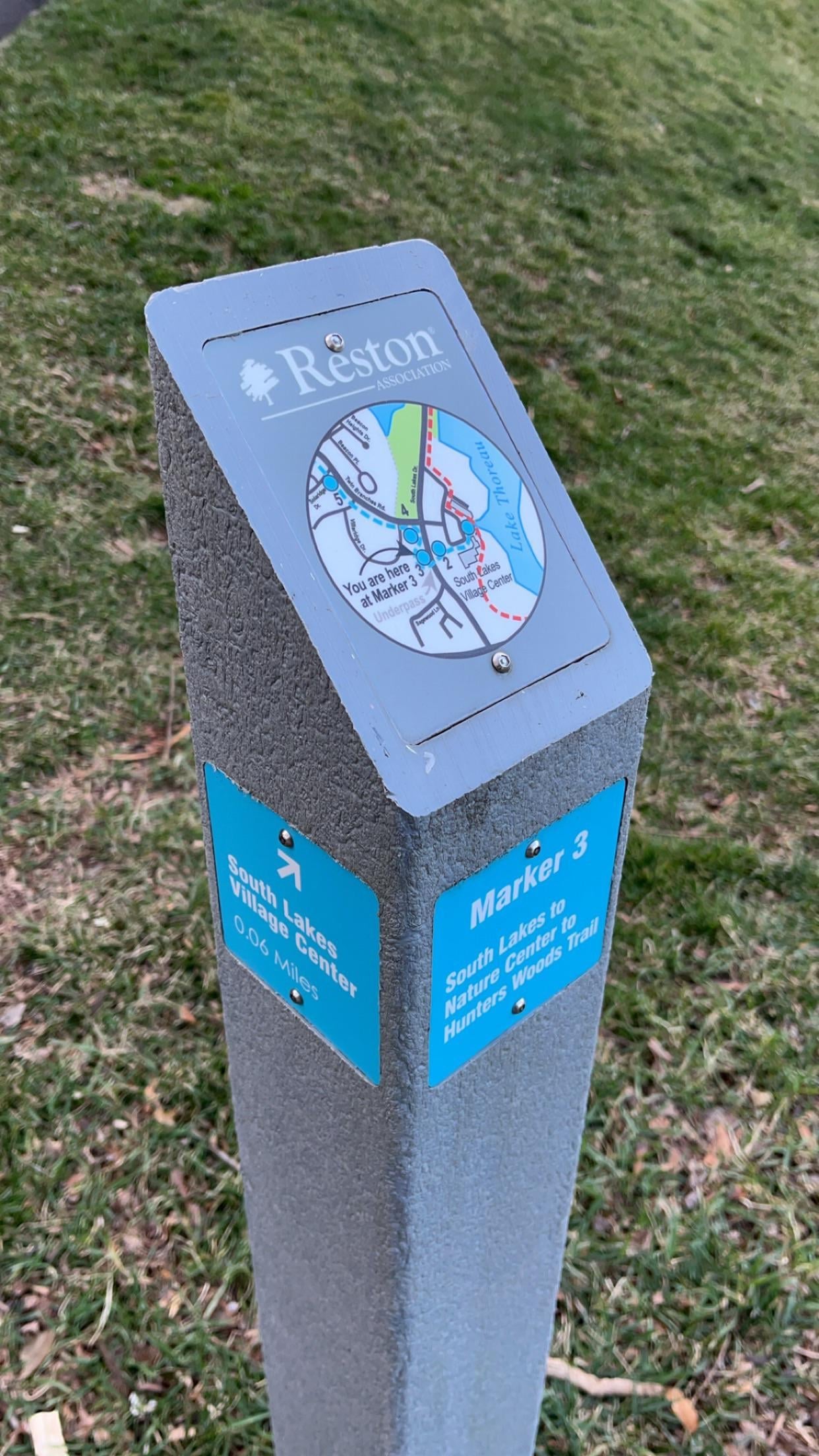
The other gray posts are not trail markers, and Reston Association gets asked about them often enough to have written an FAQ answer. Rectangular gray posts with no number, no map and no distance mark the property line between homeowner or cluster land and Reston Association open space. The older ones are concrete, the newer ones recycled lumber, and a blue square or plaque reading “RA” faces the association’s side.
All four lakes have a loop, and none of them stays on the water
Every one of the four has a qualification attached to it.
| Lake | Loop distance | Surface | Park at |
|---|---|---|---|
| Lake Anne | 1.5 miles | Paved path and sidewalk | Lake Anne Plaza |
| Lake Audubon | 2.8 miles | Paved, with a short natural section | Lake Audubon pool, Twin Branches Road |
| Lake Thoreau | 2.1 miles | Paved | South Lakes Village Center |
| Lake Newport | 1.0 mile | Paved path and sidewalk | Brown’s Chapel Park, 1525 Brown’s Chapel Road |
Every one of the four mixes shoreline pathway with cluster sidewalks and residential streets. The Lake Anne loop runs sidewalk along South Shore Road, Waters Edge Lane and Inlet Court, and crosses the Lake Anne dam on the Wiehle Avenue trail. The Lake Audubon loop includes stairs, so it will not take a wheelchair or a stroller end to end. The Lake Newport loop crosses Lake Newport Road, Grenwich Point Road and Waterfront Road at grade. And the Lake Thoreau loop, as noted above, spends most of its length away from the water.
Walking Lake Audubon and Lake Thoreau together comes to about 2.2 miles.
One rule applies to all four: swimming is prohibited in every Reston lake and pond, and so is every winter activity on the ice, including skating, ice fishing and walking out onto it.
Four stream valleys carry trails, and the Glade runs in two directions
The stream valley trails follow Reston’s creeks through woods rather than past houses. Most run as unnamed connectors rather than marked routes, so the association’s interactive map does more for you here than a brochure will.
Snakeden Branch runs a paved short loop of about 1.7 miles, or about 2.8 miles for the fuller park loop. Start at the rear of the Glade recreation area lot.
The Glade splits into two halves. The western section runs about 1.3 miles on a short loop and about 3.3 miles for the full route, asphalt and fully shaded. The eastern section runs about 2.5, 2.9 or 3.1 miles depending on which return you take, and mixes pavement with natural surface. Beavers have taken a good number of the trees near the stream on the eastern end, and the wetland there is their work.
Buttermilk Creek is the walking link from Reston’s network into Lake Fairfax Park. It runs about 1.3 miles of natural surface and pavement, or about 1.6 miles if you take the signed spur to the hill overlooking Lake Fairfax and its dam. Start at the Uplands pool on North Shore Drive at Ring Road, take the asphalt trail to the left of the pool down the pipeline right of way, and pick up the natural surface trail in the woods.
All three feed the Walker Nature Center at 11450 Glade Drive, which holds 72 acres, about a mile of its own loop trails, a pond, a fire ring, a picnic pavilion and the LEED Gold Nature House. Parking is free, the trails are open dawn to dusk, and the restrooms are open too. The Nature House keeps its own hours and closes Tuesdays.
Parking is free at every trailhead we could verify
Reston Association recreation passes gate the pools, the tennis courts and the pickleball courts. They do not gate the pathways. Nothing in the association’s published trail rules conditions use on membership, and the Walker Nature Center advertises free parking and trail access with no member requirement.
| Trailhead | Address | Cost | Access |
|---|---|---|---|
| Walker Nature Center | 11450 Glade Drive | Free | Dawn to dusk, restrooms on site |
| Lake Fairfax Park | 1400 Lake Fairfax Drive | Free, no entrance fee | Three lots inside the park |
| Brown’s Chapel Park | 1525 Brown’s Chapel Road | Free | Lake Newport loop trailhead |
| South Lakes Village Center | 11120 South Lakes Drive | Free customer lot | Red and Turquoise trailhead |
| North Point Village Center | Reston Parkway at Center Harbor Road | Free customer lot | Pink Trail start and finish |
| Hunters Woods Village Center | 2254 Hunters Woods Plaza | Free customer lot | Turquoise west end |
| Lake Anne Plaza | 1609 Washington Plaza | Free customer lot | Blue and Green trails |
| Glade recreation area | Glade Drive | Free lot, pool needs a pass | Snakeden Branch and Nature Center routes |
| Lake Audubon pool and boat ramp | Twin Branches Road | Free lot, boating needs a permit | Lake Audubon loop |
| W&OD Trail, Reston | 1891 Old Reston Avenue | Free paved lot | The main W&OD trailhead in Reston |
| W&OD Trail, Hunter Mill Road | At the trail crossing | Free | Roughly eight spaces, and the Cross County Trail access point |
| Reston Town Center | Market Street garages | First hour free; free after 5 p.m. weekdays and all day weekends and federal holidays | Green Trail east end |
Two notes on that table. The Hunter Mill lot is small enough that a weekend morning will fill it. And Tamarack Park, which shows up on some maps as an access point, has an open field and a connector trail but no parking at all.
Three larger trail systems meet Reston’s network
The W&OD Trail runs 45 paved miles from Shirlington in Arlington to Purcellville in Loudoun County, which NOVA Parks likes to call the skinniest park in Virginia. It carries roughly two million visits a year and is open 5 a.m. to 9 p.m. daily. Through Reston it is a dual trail, with the asphalt path running parallel to a stonedust path, and mileposts every half mile. Reston’s connection points are the Bluemont Way underpass just southeast of the Town Center and the trailhead lot at 1891 Old Reston Avenue.
The Gerry Connolly Cross County Trail covers 41.5 miles from Great Falls Park down to the Occoquan. Its Reston and W&OD section runs about four miles from Lawyers Road to the Dulles Access Road. The surface is asphalt from Lawyers Road as far as Twin Branches Road and natural surface or stonedust after that. You cross Lawyers Road, Twin Branches Road, Buckthorn Lane and Hunter Mill Road at grade, and there are no service facilities anywhere on the stretch. We have written about the Cross County Trail in full here.
One caution on that section. Just south of the Dulles Access Road the trail makes a large fair-weather crossing of Difficult Run, meaning there is no bridge and the crossing is impassable after rain. Check the forecast and the days before it.
Lake Fairfax Park covers 476 acres on Reston’s eastern edge and runs its own trail system, about 7.45 miles of built trail across 19 numbered segments with more phases mapped for later. The spine is the Rails to River Trail, roughly 2.5 miles running from a connection to the W&OD at the southwest corner through to Colvin Run Mill at the northeast. Fishermen’s Trail is pedestrians only. A good deal of the rest sees heavy mountain bike traffic on weekends, so weekday mornings are the better time to walk it.
Reston Association maintains 119 bridges and 25 underpasses, and two underpasses hold public art
The underpasses are the reason the network functions. Reston’s pathways cross Reston Parkway, Wiehle Avenue, South Lakes Drive, Baron Cameron Avenue, Glade Drive, Colts Neck Road and Soapstone Drive without a crosswalk, and the association’s own asset data counts 25 of them along with 119 bridges.
Most of the bridges are numbered rather than named. The exception is the Van Gogh Bridge at Lake Anne, which both the Blue and Green trails cross and which both brochures label.

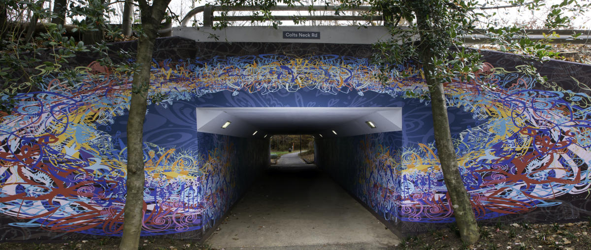
Two of the underpasses are galleries. Ben Volta’s “Thoreau’s Ensemble,” installed in 2019, covers the Colts Neck Road underpass. Valerie Theberge’s “Emerge,” from 2010, covers the Glade Drive underpass. Both sit directly on walking routes, and Public Art Reston publishes free self-guided tour maps if you want to string several pieces together.
Leashes are required, and e-bikes are capped at 20 miles per hour
Reston Association’s published pathway rules are short. Stay on established trails and pathways. Keep pets leashed and pick up after them. Leave plants and animals where you find them. Put litter in a can or carry it out. No smoking within 50 feet of a recreation area, community building or pavilion.
The leash rule carries real weight, since both Fairfax County law and association rules require it and failure to comply can bring a fine. The association stocks Mutt Mitts and waste cans along the pathways. The only fenced dog park in Reston is at Baron Cameron Park, at Wiehle Avenue and Baron Cameron Avenue, which Fairfax County runs.
Bikes and e-bikes fall under Reston Association Use and Maintenance Resolution 4, amended by member vote to cover scooters and Type 1 and Type 2 electric bikes with a top speed of 20 miles per hour. No motor exceeding 20 miles per hour is allowed on the trails, which effectively rules out Type 3 e-bikes. Riders yield to pedestrians, keep right, pass only when it is safe and give notice when overtaking, and stay on designated trails. Riders under 14 must wear a helmet.
The Walker Nature Center adds one stricter rule of its own: no smoking within 50 yards of the building, pavilion and fire ring, rather than the 50 feet that applies elsewhere.
In winter, Reston Association plows the pathways and sidewalks it owns. Sidewalks along state roads belong to VDOT.
The Glade Stream Valley Trail is the flattest route for strollers and wheelchairs
The large majority of the Reston network is concrete, asphalt or other paved surface, so the hills decide which routes work with a wheelchair or a stroller.
The main stream section of the Glade Stream Valley Trail is the most level stretch in Reston, with restrooms and water at the Walker Nature Center and several entry points that let you skip the hills. Park at the Lake Audubon pool, the Glade pool, or on Soapstone Drive.
Routes to avoid if you need level ground: the Red Trail around Lake Thoreau has steep sections, the Lake Audubon loop has stairs, Buttermilk Creek has wooden steps and culvert crossings, and the Cross County Trail section has several steep pitches plus the Difficult Run crossing.
Reston Association also offers a complimentary Companion Pass for people with disabilities, available on request.
Every map is free to download
- Reston Association Explorer map, the interactive one that will show your location on the trail, along with per-trail interactive maps for each of the five named routes, both linked from the association’s trails page
- The five printed brochures, two pages each, downloadable from that same page
- Fairfax County’s Lake Fairfax trail map, which numbers all 26 segments with distances
- Fairfax County’s Cross County Trail sheet 8, covering the Reston and W&OD section
- NOVA Parks’ W&OD overview map, which is a graphic rather than a mile-marker guide
- Fairfax County’s Sugarland Run Stream Valley map, for the Herndon side
Pathway access carries no separate fee and never shows up in a listing
Pathway access is one of the few Reston amenities that does not appear in a listing description and does not carry a fee of its own. A house backing to open space in Reston usually means a house on or near the path network, and the difference between a home 200 feet from a connector and one that requires a drive is worth walking before you write an offer.
If you are weighing neighborhoods, the Turquoise Trail corridor through South Lakes and Hunters Woods and the Pink Trail loop around North Point give you two long walks through very different parts of Reston. We would suggest doing both before you narrow the search. For more on how Reston works day to day, our living in Reston guide covers fees, schools, and the rest of it.
See something missing or wrong? Email us at [email protected] and we will check it and update the post.